Photogrammetry & mapping by drone

CONTACTEZ-NOUS
background bottom

Drone photogrammetry redefines precision and spatial analysis.

Drone photogrammetry revolutionizes mapping by using aerial images captured and processed to create accurate 3D models of terrain, buildings, and other structures. This approach offers remarkable precision in environmental representation, enabling precise planning and monitoring in diverse fields such as urban planning, agriculture, natural resource management, and many more.

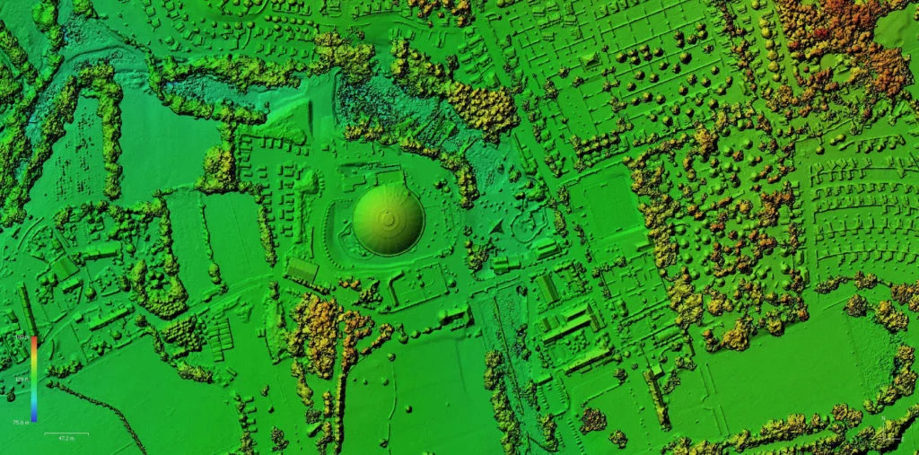
Produce a Digital Terrain Model (DTM)

Accurate representation of terrain relief is essential for numerous land management applications. By modeling both ground and surface features, the digital terrain model simplifies the representation of elevation and topography.

Produce an Orthophoto

By stitching together hundreds of images into one, orthophotography provides a georeferenced, ortho-rectified view in very high resolution (e.g., 1 cm/pixel).

Generate a Digital Terrain Model (DTM)

A digital terrain model simplifies the representation of ground elevation and topography, essential for various land management applications.

Objectives of Drone Photogrammetry & Mapping Training

Take advantage of rapid deployment and time-saving with the flexibility of drones and mission automation.

Training Objectives


Integrate drone technology within the framework of technical activity for producing georeferenced documents (orthophotos, digital terrain models, and 3D digital twins).

Pedagogical Objectives

At the end of the training, the trainee will be able to produce dense point clouds, digital models, and orthophotos for integration into a geographic information system, perform point calculations for integration into CAD / CAM software, etc.

21-hour Training Program

Training Program

GENERAL KNOWLEDGE :

Introduction to photogrammetry: principles, pitfalls, and best practices.

Presentation of different digital deliverables: point clouds, 3D meshes, 2D orthophotos, digital models.

Capture methodology: photo exposure, sensor parameterization (M/P/PV/PA), overlap, practical advice, use of automated flight applications.

PROKECT REFERENCING:

Use of Ground Control Points (GCP), RTK / PPK operation.

PRACTICAL CAPTURE WORK:

Planning and execution of a complete building survey mission.

Consideration of environmental constraints.

Measurement taking.

Management of overlap in manual piloting and photo exposure.

Control of acquired data.

POST-PROCESSING PRACTICAL WORK WITH METASHAPE PRO (CONTENT CONTROL - 2PT):

Data organization, import, referencing selection.

Introduction to the software interface and creation of the processing area.

Selection of processing options, creation of the processing diagram.

Referencing and scaling with GCPs or MTPs.

Image annotation.

Cleaning and classification of the point cloud.

Object manipulation and measurements.

Generation of orthophotos, digital surface/terrain models, contour lines, volumetrics.

Export of results for use in CAD/DAO and GIS software.

Tout public

Durée : 3 jour(s) (21 heures)

1.644,63 € HTVA
(1.990,00 € TTC)

Valeur chèques formations : 0,00 € TTC

Option(s) :

Pré-requis

Être détenteur de l’attestation de formation pratique Open ou Spécifique.

Matériel

Apporter un bloc-notes et un stylo. Tous les autres documents ou matériels nécessaires vous seront fournis sur place.

  • Drones DJI PHANTOM 4 PRO
  • capteur 1 pouces et obturateur mécanique
  • 1 station de travail informatique par élève

Prochaines formations

DU 23/04/2024 AU 25/04/2024

DU 26/06/2024 AU 28/06/2024

Lieu de la formation

Aérodrome de Saint-Ghislain,Rue des Marionville, 21, 7330 Saint-Ghislain, Belgique 

Pour les entreprises en groupes, on peut venir former directement sur place dans toutes la Blegique et plus. 

Inclus :

  • Certificat de formation
  • Veste fluo
  • Syllabus papier
  • Support pendant 1 an après votre formation